

There are three options for those who wants to climb the Acatenango. With its 3976m height, and its amazing view on Fuego, it’s the most popular volcano in Guatemala.
First option is to go on a tour with a travel agency or an hotel in Antigua. It will cost you a minimum of 350Q, but prices can be much higher depending on the service and the quality of the tour. Any hotel in Antigua, any travel agency, will offer you one of those tours. And if you ask anyone in the street, he’ll know someone to bring you there.
Second option is to go to la Soledad (the village where the Acatenango trek starts) and to find a guide there. It will cost you a minimum of 250Q. Bit more complicate to deal with, as you’ll have to go to the village and find somewhere there (ask anyone, they will help you, guatemaltec are really helpful). Positive side of this one: your money will go straight to the guide and the local economy. Not to an agency…
Third option is the one sounding the most appealing to me. Doing the Acatenango by myself. To have no time constraint. To be able to go whenever I want, and to spend as much time as I want on the top, to go down only when I’ll decide. This option is not much documented on the internet (hence this post). It is actually very simple, very nice, and very cheap. Total budget : 74Q + food).
I do strongly discourage anyone without lot of hiking experience to go on this trek without a guide. Not because it’s complicate, but because it’s hard. I also discourage you to do it on your own if you’ve never hiked a +1000m in a day at least once, or if you’ve never go over the 3,500 meters altitude before. In those conditions, I strongly suggest to do the hike with a guide. Acatenango IS THE HARDEST VOLCANO i’ve hiked in Guatemala (from the easiest: San Pedro, Santa Maria, Tajumulco, Acatenango).
Step 0 : get ready
At 3976m (summit) it’s cold. Never over +10°C, often as down as -5°C. There is lot of wind. If you start climbing in tshirt, you’ll finish with a couple extra layers on. Take something cold proof with you. Even more if you’re planning to camp at the summit instead of the base camp (see later for this point). A tent is definitely something you’ll need. It’s possible to rent one in Antigua, but prices are very hight. And of course, don’t forget a good sleeping bag, sleeping mat…
About food: plan for at least one heavy meal, a good breakfast the next morning, and cereals bars (or any energy booster, you’ll appreciate them). Three litters of water per person and per day is a good minimum.
You’ll need good hiking chose, and you’ll be happy at the end if you have a good walking stick. You can buy one for 5Q at the beginning of the trail.
Because I had the time, I planed for 2 days of food. Just in case…
AVOID AS MUCH AS YOU CAN ANY EXTRA WEIGHT!
I’m really good into carrying a heavy backpack with lot of useless things in it. Of course, it was awesome to play didgeridoo on the summit of the Acatenango. And if I had slept at base camp, with no wind and a bit warmer, I would have use my fire staff. And I had food for two days, just in case. But still… 17 kgs backpack was maybe a bit to much…
Step 1: going to La Soledad.
Like almost all my move in Guatemala, I didn’t plan how to get to la Soledad. I alway go to the bus terminal, and see how it goes. There are not much direct buses (none on sunday). I had to change at Dueñas (4Q for the first segment, 10Q for the second). Expect around 2 hours for the ride.
Step 2: find the beginning of the trail
Tell your driver you want to hike the Acatenango, he’ll know where to drop you. Otherwise, you can ask any one in the street. Or just know that the trail starts next to the cemetery, at the entrance of the village, and that there are couple of stands selling stuffs on the other side of the road. Just impossible to miss.
Step 3: the trail up to the Y (almost to the top)
Almost all groups with private guides starts around 10am. Most agencies start the climb between 10:30 and 11:00 am. Your choice to decide if you want to climb on your own or not.
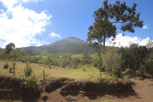
From here, the summit seems very easy to reach. That’s normal. This is not the Acatenango. Your goal is hidden behind this small little hill.
The trek is really easy to follow. Starts across fields, slowing going up. It’s not possible to get lost during all the climb. After a first hour, you’ll arrive to the entrance to the park. It’s the last spot if you want to buy an extra water bottle. You’ll have to pay the entrance fee (50Q each). Considering how clean the site is, the small building, and the quality of the trail, it’s definitely worst paying.
You’re at 2,772 meters. They promise you between 3 and 5 hours of hiking. Without telling if it’s to the top or to base camp. Considering my own time, I would say for base camp…
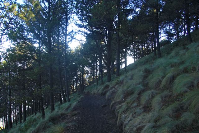
From there, you’ll keep own climbing in the trees, slowly switching from an ecosystem to an other. There are a few information poster on the way up. Every 200 meters (vertical meters) or so (a bit more than 30 minutes at my pace).
You’ll find 3 crossroad that might be a bit confusing during the hike. First one is shortly after the information about damages done by insects. Here, you take right. Second one is after the last information point (3,351 meters, the one with the panoramic view of the other volcanos). At this one, you can go right or left, as both way will join again later. And a bit after where the two trails merge again, you’ll have a 3 crossroad. In front of you, small clear spots in the trees, more or less looking like terraces. On your left, the trail goes up a bit steep. On your right, it stays more or less horizontal. If you go left, you’ll go straight to the summit. If you go right, you’ll reach base camp.

Right : you’re almost there!
Left: only 300 meters more to climb…
Summit or base camp, then ?
– base camp is around 3,700 meters. From the Y crossroad, there’s almost no hike up involved.
– summit is at 3,976. Almost 300 extra meters to climb. And those are the hardest. The last 100 is really steep, on small gravel. You’ll spend a lot of time slippering. With more than 1,200 meters in my legs already, I did suffer (took me an hour to climb this last 100 meters).
-> forget the summit if your legs are dead!
– the view on Fuego from base camp is really nice, and protected from the wind
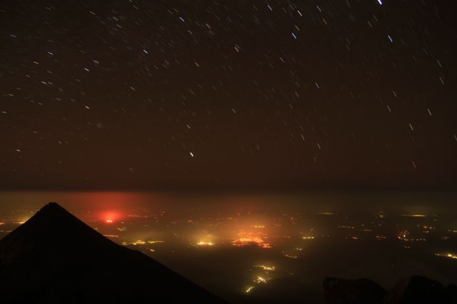
– the summit has a panoramic view on Fuego; you’ll see it from the top, but you’ll be in a windy spot!
-> if you’re worried about being cold, go for base camp. If you want the most incredible views, go from summit. And you’ll be first sport for sunrise!
– everybody sleep at base camp. I counted a bit more than 50 people going up on sunday morning. Same number on monday morning. There will be people at base camp.
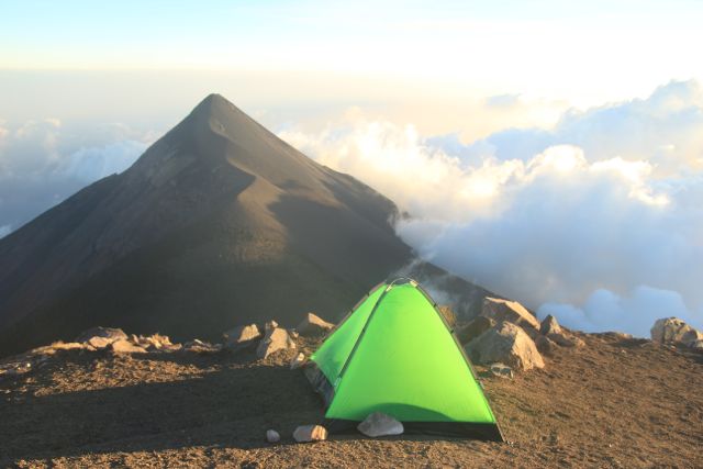
– no one is stupid enough to climb those extra 300 meters to sleep in open wind. I did have Acatenango summit just for myself!
-> social mood? looking for loneliness? you decide!
If it’s possible to sleep on the rim, like I did, take this option with lot of precaution: at 4,000 meters, wind can be extremely strong, and few people died when there tent was taken by the wind. Never forget that past 3,000 meters, you’re in height montain condition, and that includes quick and strong weather strange. If you really want to sleep on the top, the crater (protected from the wind) is safer than the rim.
Step 4: only 300 meters left!
Lot of people go to base camp to enjoy the view on Fuego, but don’t reach Acatenango summit. Which is a big mistake. A totally understandable mistake if you’re legs are really tired or if you have headaches because of the altitude.
Otherwise, if you’re in shape, go to the summit! It’s much more easy to get there on the second day. Sleep at base camp, and then morning, climb up with a very light backpack. For sunrise if you like waking up early, or just for the view, because it’s awesome!
Trail to summit (from Y crossroad) is easy to follow. When you get to the Cumbre (flat spot just before the summit), if you’re in the same situation as I was (lost in the cloud!) know that you have to take the trail going right. If you go left, you’ll reach an other summit. Smaller, with no view on Fuego.
As I wrote, the last 100 meters (up) from here are hard. You’ll enjoy the stick, specially if you’re with a full backpack!

Step 5: going down
If you have enough time, plan for two nights on the Acatenango. Sleep at base camp for the first night, take the second day easy by going up and down the summit, and running in the gravels. And spend hours watching Fuego and the amazing landscape around! Keep the way down for the third day.
It took me a while before I decided to go down on the second day. If didn’t have a good sleep on the summit (to much wind, was a bit cold) and I didn’t want a second night like this one. I was also a bit pressed by time. I wasn’t sure, thinking that sleeping might be better at base camp (was confirmed to me later, for there’s no wind there). Well.. I’ll go back there anyway. Taking more time this time.
Going down is fast. Expect 3 hours. Even less if you like running down like crazy (and if your legs are okay). Took me 6 minutes to go down the last part that took me one hour to go up the previous day…
There’s a chicken bus at 11am going to Chimal, but you can catch a correspondence in Parramos with a second chicken bus. Will cost you 10Q (7Q for the first segment, 3Q for the second). There are other buses in the afternoon, and probably pickups stoping if you wave to them.
Buses from agencies usually have extra seats. I asked, for curiosity, a driver. It told be that the agency request 50Q per passenger. So it’s possible, but viewing the price, I strongly discourage that. Maybe other will ask less, but I do have a doubt.
[I’ll go back on all that in a couple of months, after doing the Acatenango again, over 3 days, so I can talk more about base camp]
Good reason to sleep on the top. Don’t you think so?
Laisser un commentaire
- Accueil
À propos de l’auteur

Auteur de quatre livre (la trilogie du Pourquoi Pas et Fille de la route), conteur, photographe, musicien et parfois graphiste, je suis mon instinct, mes envies et mes rêves sur le chemin de la vie et sur les routes du monde.
Nomade depuis 2010, vagabond à temps partiel et bohémien dans l'âme, je parcours les routes et partage ici mes expériences. [En savoir plus]Mes livres
En savoir plus sur mes livres
déjà auto-édités :
À Vancouver, tourne à gauche
En Oregon, tourne en rond
À Portland, tourne la page
Fille de la route